Forestry
Forests of Pakistan, from northern mountains to coastal mangroves are richly bio-diverse and present a fair blend of flora and fauna across different ecological zones throughout the country.
Satellites are reliable rapid earth observation tools. Remote sensing with its capability to acquire temporal images in different spectral regions has the potential to map and monitor biosphere. Important areas of application are;
- Forest Cover assessment and classification
- Surface and subsurface carbon stock assessment
- Afforestation and deforestation monitoring
- Forest health monitoring
- Forest fire monitoring and damage assessment
- Forest species distribution modelling
- Biodiversity and ecosystem monitoring
Forest Carbon Stock Assessment using Geospatial Technologies Project

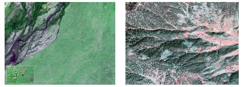
Forest Carbon Stock of the Study Area using GF Satellite Dataset
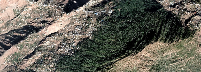
Pakistan Space and Upper Atmosphere Research Commission (SUPARCO) initiated a collaborative research study with Asia Pacific Space Cooperation Organization (APSCO) and its Member States (MS) having intangible benefits in the form of capacity building for qualitative as well as quantitative assessments of above ground forest carbon stock using advance satellite datasets. The datasets explored during the study included optical (Gaofen) and Synthetic Aperture Radar (ALOS2 PALSAR-2) satellite datasets acquired for the years 2019-2020. The coniferous forest located on Himalayan mountain range was the study area for the research study. The satellite dataset were preprocessed for geometric and radiometric errors followed by atmospheric and topographic corrections. The study also involved field data collection including above ground forest carbon estimation in tree, shrubs, herbs and litter samples. Finally, multiple regression technique was used to map above ground forest carbon stock in the study area using Normalized Difference Vegetation Index (NDVI), Enhance Vegetation Index (EVI), entropy texture of blue and green bands, reciprocal of green band and correlation texture of principal component 1 as input variables. The study concluded that satellite image based estimation of forest carbon stock could be carried out using satellite datasets with overall accuracy greater than 80%.
Mangrove Watch from Space Project
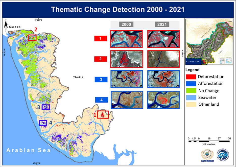
Thematic Change Detection of Mangroves Forest from 2000 to 2021
Pakistan Space and Upper Atmosphere Research Commission (SUPARCO) initiated a collaborative research study with Asia Pacific Space Cooperation Organization (APSCO) and its Member States (MS) to map mangroves in the Indus Delta region using Landsat and high resolution GF-2 satellite datasets for the years 2000 – 2021. The preprocessed satellite datasets were transformed using principal component (PCs) analysis into PC band combinations followed by extraction of atmospherically resistant vegetation index (ARVI) and fractional vegetation index (FVI). Afterwards, the three layers (PC band combination, ARVI and FVI) were used to categorize satellite dataset into four classes including Mangroves Forest, Grasses, Other land and Seawater using Random Forest technique with overall accuracy of 88%. The thematic maps were then used to perform change detection from 2000 – 2021 to show Afforestation, Deforestation and No change in mangroves forest of the Indus Delta.