Disaster Management
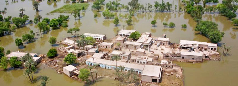
Natural disasters are a major risk to a country’s sustainable development. The vulnerability to disasters can be minimized with accurate forecasts, early warnings and damage assessments. Remote sensing and Geographic Information System (GIS) have supportive tools in all the phases of disaster i.e., prevention, preparedness, early warning response and rehabilitation. Important areas of application are;
- Monitor, forecast and map various hazards
- Damage assessment in affected areas
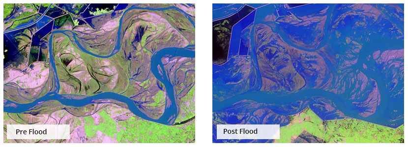
- Integrated Flood Analysis System
- Disaster vulnerability assessment (earthquake, landslide, flood, cyclone, tsunami, drought, heat)
- Risk modeling
- Rehabilitation and mitigation support
SUPARCO’s Space Application Center for Response in Emergency and Disasters (SACRED)
SUPARCO’s Space Application Center for Response in Emergency and Disasters (SACRED) was established in 2013 to provide space based technical support to National Disaster Management Authority (NDMA), Provincial Disaster Management Authorities (PDMAs) and other national organizations during natural disasters using satellite remote sensing technologies, GIS and other data. The centre is equipped with state of the art facilitates including required software and hardware for space based information processing and dissemination. Major function of the SACRED are:
- Provision of the space based information to NDMA and PDMAs in the event of the natural disasters (Flood, Drought, Earthquake, and Landslide) for mitigation, preparedness, response and recovery
- Activation of the International Charter Space and Major Disasters in the event of the major calamity
- Technical support to the NDMA and PDMA for the conduct of the Multi Hazard Vulnerability and Risk Assessment (MHVRA) Studies
- Capacity building of the NDMA and PDMAs in the field of space based disaster management
- Technical support to the NDMA for the realization of the long-term agenda including NDMP 2015-30, Sendai Framework 2015-30, Paris Climate Change Agreement COP21 and SDGs 2015-30
- Provision of space based information/support to the regional countries in the event of the natural disasters
SUPARCO is host to the UN-SPIDER Regional Support Office in Pakistan namely Pak-RSO since 2010. In addition, SACRED Dte is the Data Analysis Node of the Sentinel Asia Joint Project Team Initiative since 2014. More recently, SUPARCO joined APSCO Disaster Management Framework. Last but not least SACRED-SUPARCO is the member of the International Charter Space and Major Disasters. SUPARCO activate International Charter Space and Major Disasters whenever NDMA declare any disaster as Major calamity.
In such situation, all space agencies provide free of cost data to SUPARCO for rescuer, relief operations. SUPARCO, being the National Space Agency & member of UNCOPUOS/Space Mission Planning Advisory Group (SMPAG) is the focal point in receiving information about Near-Earth Objects (asteroids and comets) and passing on to the NDMA as well as PDMAs.
SACRED-SUPARCO provides near real time support to NDMA/PDMAs through DisasterWatch Web Portal which can accessed at Disaster Watch
Natural Catastrophe Modelling (NatCat Model) Project
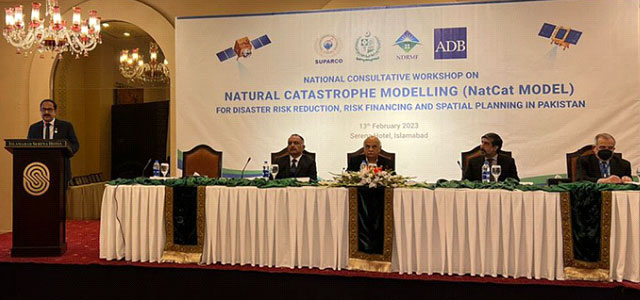
National Consultative Workshop on NATCAT Model project, 13th Feb 2023, Islamabad
Space Applications Centre for Response in Emergency and Disasters (SACRED), a Directorate of Space and Upper Atmosphere Research Commission (SUPARCO), Pakistan, is host to UN-SPIDER Regional Support Office (RSO) in Pakistan. PAK RSO is presently undertaking the “Development of Geo-referenced Exposure Database for Catastrophe (NatCat Model)” Project for National Disaster Risk Management Fund (NDRMF). Main components of the project include; floods, droughts, earthquakes and cyclones probabilistic hazard assessment, exposure and vulnerability assessment, financial risk assessment and development of a spatial database and WebPortal. NatCat Project will eventually help in reducing socioeconomic and financial vulnerability of the country and its population to natural hazards by prioritizing and financing investments in disaster risk reduction and preparedness. The project will also assess impacts of climate change on flood, drought and cyclone hazards frequency and magnitude. The model will eventually help in physical vulnerability and risk assessment on national level against seismic and hydro-meteorological hazards.